Friday, July 31, 2015

Caught In A Landslide


Something about Section 189 on the North Ridge has always struck me as odd.

It's at an extreme corner of the Cemetery near the North Pond.  Behind the fence, traffic passes on Spring Street and houses have sprung up in the years since I first started exploring.  Sounds from Siena College often carry over.

The stones in this field are arranged very neatly and almost all face the same direction.  It's quite symmetrical compared to most lots where the monuments face whatever direction the owners wanted which gives the older sections a pleasantly disorganized look.


Many of the stones here are fairly old in what is a relatively newer section.  It doesn't appear on the extremely useful 1912 lot map, yet many of the stones predate it.  A search of all burials in Section 189 shows that burials in this section only began in 1941,, but clearly some of these stones are far older.  Many date from the mid to late 1800s.


Researching a few of the names found on the older stones revealed another interesting detail.  I picked one of the names - Charles Angus who died in 1875 - and checked the burial index cards which showed he were buried in Lot 22, Section 89. 

Several of the Angus family stones in Section 189

For a moment, I thought it could be a typo - that perhaps it was supposed to read "189," but the "1" was accidentally omitted.  A check of a few other names, however, showed they were all listed as buried in Section 89. 


Several years ago, when I began my research, I came across a passing reference to a landslide in a back issue of the Friends of the Albany Rural Cemetery's newsletter.  More recently, I found a brief article in the defunct Knickerbocker News describing a court case in which the Cemetery sought and obtain permission to move a number of graves which had been affected by a landslide.  The article didn't mention what part of the Cemetery had been damaged by the landslide, but the connection was clear.

In 1951, a landslide caused part of Section 89 to collapse.  Section 89 overlooks the Kromme Kill ravine and the remains of Lake Bathesda.  The landslide caused some graves and monuments above the old Bramble Copse walk to tumble into the ravine.

Detail of an 1871 map showing Section 89.

As a result of the landslide, approximately 150 graves had to be removed from the portion of Section 89.  The article didn't mention where the graves were going to be placed.  However, a second check of records for the Angus family and a sample of other names on those older monuments in that far corner of Section 189 showed they were all not only listed as Section 89, but most came from lots along the edge of the ravine overlooking Bramble Copse Walk.

Map from 1912 showing the original location of the Angus lot on the ravine side of Section 89.  The wavy parallel lines in the lower left of the corner are part of the lake.

These monuments seems subtly out of place because, in a way, they are.  The older gravestones in Section 189 are those which were relocated after the 1951 landslide damaged Section 89.


Wednesday, July 22, 2015

Vandalism Incident

Two monuments - a vault and a headstone - were vandalized recently.  News10.com has details and video in the link below.  If you have any information on the incident, please contact the Colonie Police Department at (518) 783-2744.

News10.com - Albany Rural Cemetery vandalized

Paul Grondahl, of the Times Union, has an excellent article on the incident.

Vandals desecrate mausoleum, grave marker at Albany Rural Cemetery

Sunday, July 12, 2015

Glen Cross Bridge


In the past, a number of small bridges cross the Cemetery's streams and ravines, conveniently linking the North, Middle, and South Ridges for visitors following the "Tour" route laid out in such books as Henry Fitzgerald's Guide Through The Albany Rural Cemetery.  Very few of the bridges survive now, including the Glenn Cross Bridge.

One of the most highest and most scenic of the old bridges, Glenn Cross spanned a narrow ravine that cuts into the South Ridge.  The southern end of the bridge was the path from Section 5 and the northern end was the path between Sections 9 and 10 (near the circular plot of Francis Dwight).

The picture above is scanned from an antique stereoview in my personal collection.  The original photograph was taken from the north side of the span and looks south across it toward the monument of Harmanus Bleecker.  The previously mentioned Dwight enclosure is just behind the photographer.

The looping old Tour route laid out on older Cemetery maps passes both across the bridge and beneath it.  The early Cemetery map printed by John Gavit identifies the path beneath the bridge as "Glenwoodie."  Later maps label the approach to the bridge from the south as "Glen Crossway" and the north approach as "Ravine Crossway."

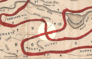
The highlighted circle on this 1871 map shows the location of Glen Cross Bridge with Consecration Lake to the upper right.

 A recent view from the north side.  The stone abutments are all that remains of Glenn Cross Bridge. 


Friday, July 10, 2015

Spencer Stafford


When the Hallenbake Burial Ground, the last family cemetery in Albany, was removed from the corner of South Pearl and Hamilton Street in 1860, the remains of Spencer Stafford and his family were among those transferred to the Rural Cemetery's North Ridge.

A native of Rhode Island, fifteen year old Stafford came to Albany in 1787..  His brother, Thomas, and other relatives had already settled in the city and young Stafford became an apprentice in Thomas' Market Street store.  At the age of nineteen, he married into the Hallenbake family when he wed Dorothea.  The couple built a home on the Hallenbake land, but in 1790, relocated to Deerfield, Oneida County where Stafford was briefly engaged in the manufacture of potash.  A year later, however, the Staffords returned to Albany permanently. 

Stafford was described as "self-reliant, industrious, and enterprising" and as possessing "qualities essential to mercantile success."  A silversmith as well as a merchant, he also entered into the stovemaking business and  held various civic positions, including service as a city alderman.

Spencer Stafford would eventually build a mansion on Lydius Street;  the house still stands as 100 Madison Avenue.

Dorothea Stafford died in 1806, two years before Spencer built the Lydiys Street house.  The couple had five children.  A year later, Spencer Stafford married Harriet Romeyn by whom he had four more children.  Portraits of both Spencer and Harriet are now in the collections of the Alban Institute of History and Art and appear in their digital collections:

Portrait of Spencer Stafford by Ezra Ames
Portrait of Harriet Romeyn Stafford by Ezra Ames

Spencer Stafford died on February 10, 1844.  He laid to rest in the Hallenbake family's burial grounds where his first wife was already buried.  Harriet Romeyn Stafford survived her husband by five years and, after her death on July 5, 1849, was also buried in the Hallenbake cemetery.  In June 1860, all remains from this family burial ground were removed to the Rural Cemetery.  A sandstone monument marks the Staffords portion of the large Hallenbake plot.  Footstones with their initials mark the graves of Spencer, Dorothea, and Harriet while inscriptions on the sandstone monument memorialize

Wednesday, July 1, 2015

A New Facebook Page


As I continue to work on my book, Albany Rural Cemetery - Beyond The Graves - I always find photos and resarch to share that don't quite fit a blog post (a link, an anecdote, a photo such as the one above).  So I've created a Facebook page for the project and I would be very happy if you'd join me there, too.  You're also more then welcome to post on the new page, too.  I look forward to it.

Albany Rural Cemetery - Beyond The Graves on Facebook