Sunday, July 12, 2015
Glen Cross Bridge
In the past, a number of small bridges cross the Cemetery's streams and ravines, conveniently linking the North, Middle, and South Ridges for visitors following the "Tour" route laid out in such books as Henry Fitzgerald's Guide Through The Albany Rural Cemetery. Very few of the bridges survive now, including the Glenn Cross Bridge.
One of the most highest and most scenic of the old bridges, Glenn Cross spanned a narrow ravine that cuts into the South Ridge. The southern end of the bridge was the path from Section 5 and the northern end was the path between Sections 9 and 10 (near the circular plot of Francis Dwight).
The picture above is scanned from an antique stereoview in my personal collection. The original photograph was taken from the north side of the span and looks south across it toward the monument of Harmanus Bleecker. The previously mentioned Dwight enclosure is just behind the photographer.
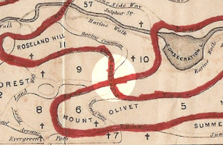
The looping old Tour route laid out on older Cemetery maps passes both across the bridge and beneath it. The early Cemetery map printed by John Gavit identifies the path beneath the bridge as "Glenwoodie." Later maps label the approach to the bridge from the south as "Glen Crossway" and the north approach as "Ravine Crossway."
The highlighted circle on this 1871 map shows the location of Glen Cross Bridge with Consecration Lake to the upper right.
A recent view from the north side. The stone abutments are all that remains of Glenn Cross Bridge.
Subscribe to:
Post Comments (Atom)


No comments:
Post a Comment